The Camden to King's Cross Walk
Page 1 of 2
The Walk
This is a walking guide to the canal towpath from Camden to the London Canal Museum in King's Cross walking west to east. It tells you about the history of the route that you're walking along and points out to you the interesting things that there are to look at on the way. It is designed to be read on your mobile as you walk. The walk will take you about 40 or 50 minutes, depending on how fast you walk and how much time you spend looking at things on the way. The route is suitable for wheelchair users. There are no toilet facilities on the route.
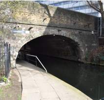
Start: Hampstead Road Lock, Camden
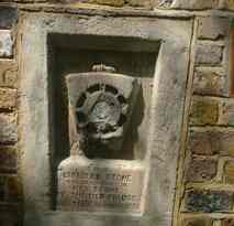
Start beside Chalk Farm Road, Camden at Hampstead Road Lock. This was the terminus of the canal from 1815-20 and site of the failed hydro-pneumatic lock which tried to raise and lower boats in tanks. Just before you descend under the first bridge, look at the stone that is set into the wall. It is the keystone of the first bridge to have been built at this site. We do not know the meaning of the symbols on it but we know it was placed here when the old bridge was replaced in Victorian times by a new and stronger bridge. It may be that the original bridge had a keystone, unlike others on the canal, because it was the last to be completed when the canal was built. Walk on to the next lock down.
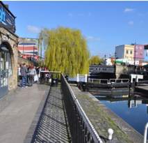
Hawley Lock.
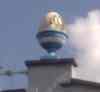 To
your right was Camden Brewery, now a TV studio. It was the birthplace of
breakfast TV in the UK - hence the egg cups on the roof! The wide section here
is one of the few places where a full-length narrowboat can turn around. Go on
to the next lock down.
To
your right was Camden Brewery, now a TV studio. It was the birthplace of
breakfast TV in the UK - hence the egg cups on the roof! The wide section here
is one of the few places where a full-length narrowboat can turn around. Go on
to the next lock down.
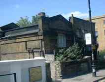
Kentish Town Road lock. There was once a steam pumping station on the left beside the lock to return water to the higher level above the locks. The picture below shows it soon before demolition. There are two lock chambers here but you will notice that one is disused. Originally all the locks had two chambers because the canal was so busy. Now only Hampstead Road Lock, where you started, has two in use. Under this bridge and on to next bridge.
The building to the right immediately after Kentish Town Road lock and the bridge, is the work of the famous architect Sir Nicholas Grimshaw. Behind the housing development is a Sainsbury's supermarket.
Camden Street Bridge. Notice the grooves in the rope guards at both ends of the bridge. These were caused by the towing ropes of horse-drawn boats. When wet and dirty with grit, the ropes would rub on canalside structures and eventually make grooves in all sorts of things. The cast-iron protection was there to protect the softer brickwork.
Camden Road Bridge. There is a flat section that you can see as you pass underneath. The bridge was modified when electric trams were introduced, because trams could not go over a humped-back bridge.
Royal College Street Bridge. The college in the name is the Royal College of Veterinary Surgeons.
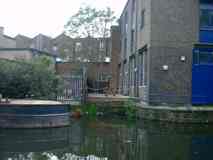
Eagle Wharf, is to the right just round the bend after the last bridge. The building with the blue doors is a former forage warehouse. See the remnants of the former basin to the left, now covered by decking. Note the remains of the crane mounting for lifting goods from boats. It was typical of the canals to see warehouse doors one above the other for unloading using a winch or crane to the upper floors. This building, although not particularly notable in itself, is a relatively rare reminder of a type of building that was once very common beside canals.
Grays Inn Bridge. and The Constitution pub. Note the foundation stone in opposite wall. It commemorates the rebuilding of the bridge in the late 19th century. The pub one turned its back on the canal with walls that prevented drinkers from seeing the passing boats but, in a sign of changing times, it now makes the most of the view. After here you will see modern canalside property development to the right and, to the left, a viewing platform for local residents to enjoy, above the canal. Just beyond this is an oblong indentation in the canal, a bit like a lay-by. In fact this is a horse ramp. If a horse fell in the canal the boatman would need to untangle it from the harness and lead it out, probably with much use of bad language by the boatman. The ramps were provided to make this easier. You can see the slope down into the water starts at the first end that you come to.
The modern ugly warehouse building opposite is best overlooked, but you might wonder what the Jubilee Centre is to the left. This is a youth activities centre. Continue to just before the next bridge, at an oblique angle to the canal.
Oblique Bridge. The road above is Camley Street. The Landowner fought long legal battles with the canal over building this stretch. Just before the Oblique Bridge you will see the remains of gates in the water either side of the canal and a narrower section. These were buildtalong with other sets of stop-gates during the Second World War. Because the canal passes above the main railway from King's Cross to Scotland, there was a fear that enemy bombs might breach the canal and flood the railway. The stop-gates were closed during bombing raids to limit the potential damage. In fact the canal was never seriously damaged.
Just after the oblique bridge is a pair of bridges carrying the main-line railways from London to the East Midlands and Yorkshire, and the high speed line to Paris and Bruxelles. The old facades of the former bridges have been re-used for decorative effect. It is because of the canal that St. Pancras Station is at a higher level than King's Cross. One engineer chose to build over the canal, the other went beneath it in a tunnel.
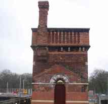
St. Pancras Basin and Lock. The basin was built in 1867 for railway ash disposal. Now it is home to St. Pancras Cruising Club, and a new dry dock. Note the lock keepers cottage, C1890, which also contained a steam pump for "back-pumping" i.e. returning water back to the higher level after locks had been used.
Behind the lock cottage is the St. Pancras water tower, moved to this site from its original position to free space for the reconstruction of the station, in preparation for Eurostar trains. This is a railway water tower, provided to supply steam locomotives with water. The office of the architect of St. Pancras Station, Sir George Gilber Scott, was responsible for its design. The tower was moved in sections by a huge crane. It is occasionally open to the public. .
Immediately beyond the lock the towpath goes over a bridge. This bridge is apparently a bridge over nothing but there was once an entrance below it into a canal basin to serve the huge railway complex and the famous Granary building.
![]()