The Mobile Towpath Walk
Page 2 of 2
On from St. Pancras
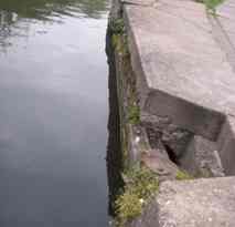
Just a little way along the canal from the bridge over the former entrance to a basin, is another horse ramp. like the one you saw earlier in the walk. Often they were sited near railways in case horses were frightened by steam trains and bolted, and fell in.
To the left was the Midland Railway stables and a horse hospital. In the brick wall we can see the remains of arches and windows. Behind here were the stables. The big tall canalside building to the left of the towpath further along is the Coal and Fish offices of the Great Northern Railway. On the opposite side of the canal you can see Camley Street Natural Park. Formerly railway sidings came overhead and dropped coal into large coal drops and a traverser on this site, designed by Samuel Plimsol. The site has now been turned into an urban oasis by the London Wildlife Trust. Go on to the narrow section of the canal ahead, where there was once a bridge.
Former Somers Bridge. Here we can see the remains of another set of stop gates in the canal bank. Just a little way further on, the canal passes over the top of the main King's Cross to Scotland railway line, which enters a tunnel just after it leaves King's Cross Station. The gates protected this railway from the possibiulity of a devastating flood.
A brand new bridge has been constructed recently to give access into one of the biggest property development sites in the UK, the King's Cross Railway Lands.
Now continue until you see the canal suddenly become much wider. To the right was the entrance to a basin for the gas works that was built here in 1823 by the Imperial Gas Light and Coke Company. Gas was made from coal then, and the coal was brought in by canal boat from the docks. Go on to next bridge but stop before you go under it, stop and look at the nondescript building on the left. This is a pumping station, but it does not supply the canal with water. It pumps water to cool the high voltage electricity cables that are located beneath the towpath along the canal, distributing electricity around London. Incidentally, you have just crossed over the top of the main London to Edinburgh railway.
Maiden Lane Bridge. The bridge was rebuilt in 1998 to carry modern traffic in keeping with the earlier style. The road above is today called York Way but it was once called Maiden Lane, and we often retain old names on the canal system. The name is not as nice as it sounds. It comes from the word "Midden", an old name for a rubbish dump, a place where night soil from London was dumped. Go on to view Battlebridge Basin, which you will see on the opposite side of the canal.
Battlebridge Basin was built 1820-25. Originally it was called Horsfall Basin after William Horsfall, the landowner. Both names are equally valid. Battlebridge is the old name for this part of London. The Battle is said to have been fought between Queen Boudica and the Romans in AD56 but few of the facts are known for sure. The story that Boudica is burried beneath one of the platforms of King's Cross Station is almost certainly myth!
Around the basin there was a flour mill, jam factory, timber yards, beer bottling, and warehouses including the ice warehouse that is now the London Canal Museum building. You cannot have failed to notice the big modern building on the opposite side of the canal, on the corner of the basin. This is King's Place, a modern concert halls and arts complex, combined with offices on the upper floors.
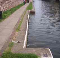
Directly opposite the basin is another horse ramp. The dark brick wall opposite the basin is nearly intact and dates back to the earliest days of the canal when the whole route was fenced or walled and those without good business to be there were forbidden to trespass. Go on to the tunnel that you can probably already see ahead. The buildings on the opposite side were once canalside warehouses or the sites of them.
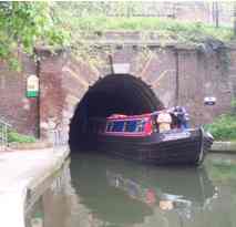
Islington Tunnel Completed 1819, by James Morgan, Engineer of the Regent's Canal, and the major work of his life. It is 960 yards long. It was built from four shafts sunk from above and then opened up into a small tunnel, before being enlarged to the full size. It is perfectly straight, in 1819 quite an achievement. There are about three million bricks in the tunnel. At first it was worked by manual legging. Legging means men lying down on top of the boat pushing with their feet on the walls or roof of the tunnel. Professional leggers were available to help, for a fee. There was a tunnel keeper's house at each end of the tunnel and these officials were responsible for regulating traffic.
From 1826 to 1927 the tumnnel was served by a steam chain tug which pulled itself and boats along by winding a fixed chain around a drum on board the boat. A steam engine on board wound the drum and several laden wide-beamed barges could be towed at a time. This was a huge improvement in efficiency compared to legging. There is room for two modern narrowboats to pass in the tunnel but normally boats wait for it to be clear before entering, nowadays.
End of the Mobile Walk. Return from the tunnel mouth to the main road and go up to street level. Turn south (walk past Canal 125 pub which should be on your right) and turn right into All Saints Street. Go to the end of this street and you will be able to see the museum. We hope you have enjoyed the Mobile Walk - do visit the museum. There is an audio tour of the museum available.
![]()